.svg)
.svg)
Protecting the Grid: Forsite's Science-Based Approach to Utility Wildfire Risk
As wildfire risk to utility infrastructure grows, Forsite delivers rigorous, data-driven Wildfire Management Plans that help utility providers protect their assets, ensure operational continuity, and mitigate wildfire risk.
Introduction
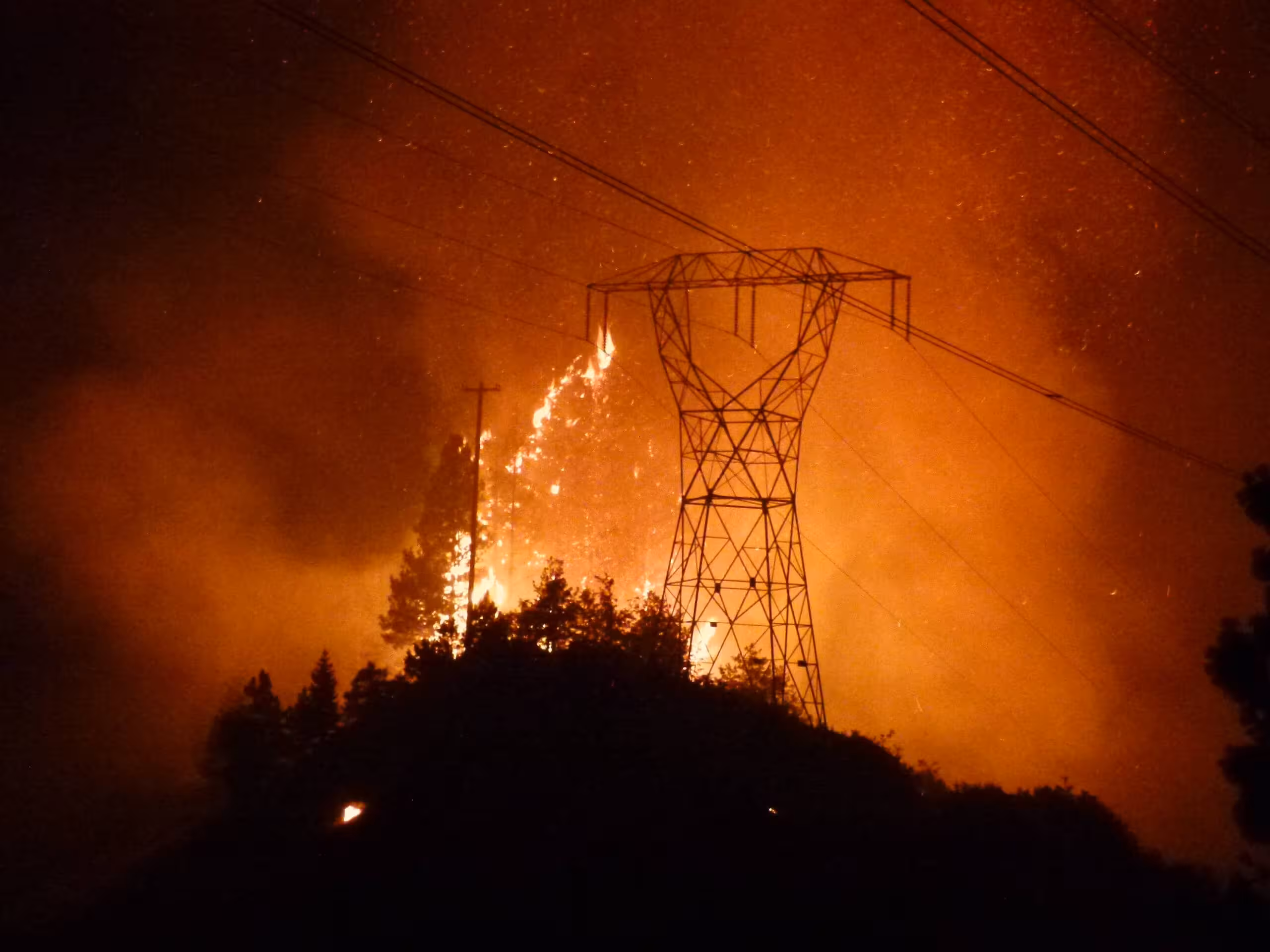
Utility infrastructure and wildfire are an increasingly dangerous combination. Power lines, transmission corridors, and associated assets are both vulnerable to wildfire and, in some cases, a potential ignition source. For utility providers operating across fire-prone landscapes, the question is no longer whether wildfire risk needs to be managed. It’s how to manage it effectively, at scale, and in real time.
Since 2019, Forsite has been delivering utility wildfire risk assessments and management plans across Canada. By combining desktop analysis, field validation, advanced fire behavior and risk modeling, and remote sensing technology, Forsite helps utility clients move from reactive risk awareness to proactive, science-backed resilience.
Key Takeaways:
- Province/territory-scale wildfire risk assessments for utility infrastructure
- Combines desktop analysis, field validation, and wildfire spread modeling
- Integrates Forsite's Fuel ID tool for current, validated and high-resolution fuel mapping
- Daily wildfire risk updates to support real-time operational decisions during fire season
- Covers Western and Eastern Canada—ongoing since 2019
The Challenge: Infrastructure at the Intersection of Fire and Operations
Utility providers face a uniquely complex wildfire challenge. Their assets span vast, often remote landscapes — crossing through forests, grasslands, and wildland-urban interface zones where fire behavior can be difficult to predict and fast-moving.
At the same time, utility operations can themselves influence wildfire risk, through vegetation contact with lines, equipment ignition under dry conditions, and the difficulty of accessing remote infrastructure for inspection or suppression.
Managing this risk requires more than a one-time assessment. It demands a continuously refined understanding of fuel conditions, weather patterns, fire behavior, and risk exposure — updated as the landscape and climate change.
The Solution: Integrated Vegetation and Wildfire Risk Management
Forsite's approach to utility wildfire risk management is built around five interconnected capabilities:
- Remote Sensing & Advanced Vegetation Analysis
- Fuel ID Integration
- Wildfire Risk Management Plans
- Wildfire Spread Modeling
- Situational Awareness Tools
1. Remote Sensing & Advanced Vegetation Analysis
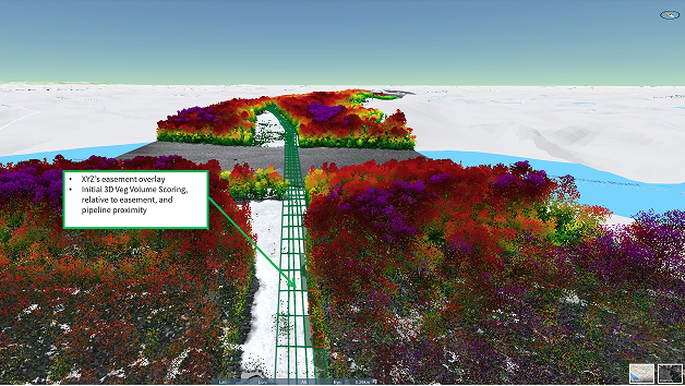
Forsite applies its Tree ID technology to map vegetation along utility corridors at the individual tree level. Built on machine learning and LiDAR remote sensing, Tree ID identifies and attributes each tree by species, height, and canopy structure, then locates it relative to infrastructure. Forsite has used Tree ID to inventory vegetation along more than 160,000 miles of utility lines across North America. That corridor-level detail tells utility teams what is growing where, so vegetation management and risk reduction can be directed to the spans that need it most.
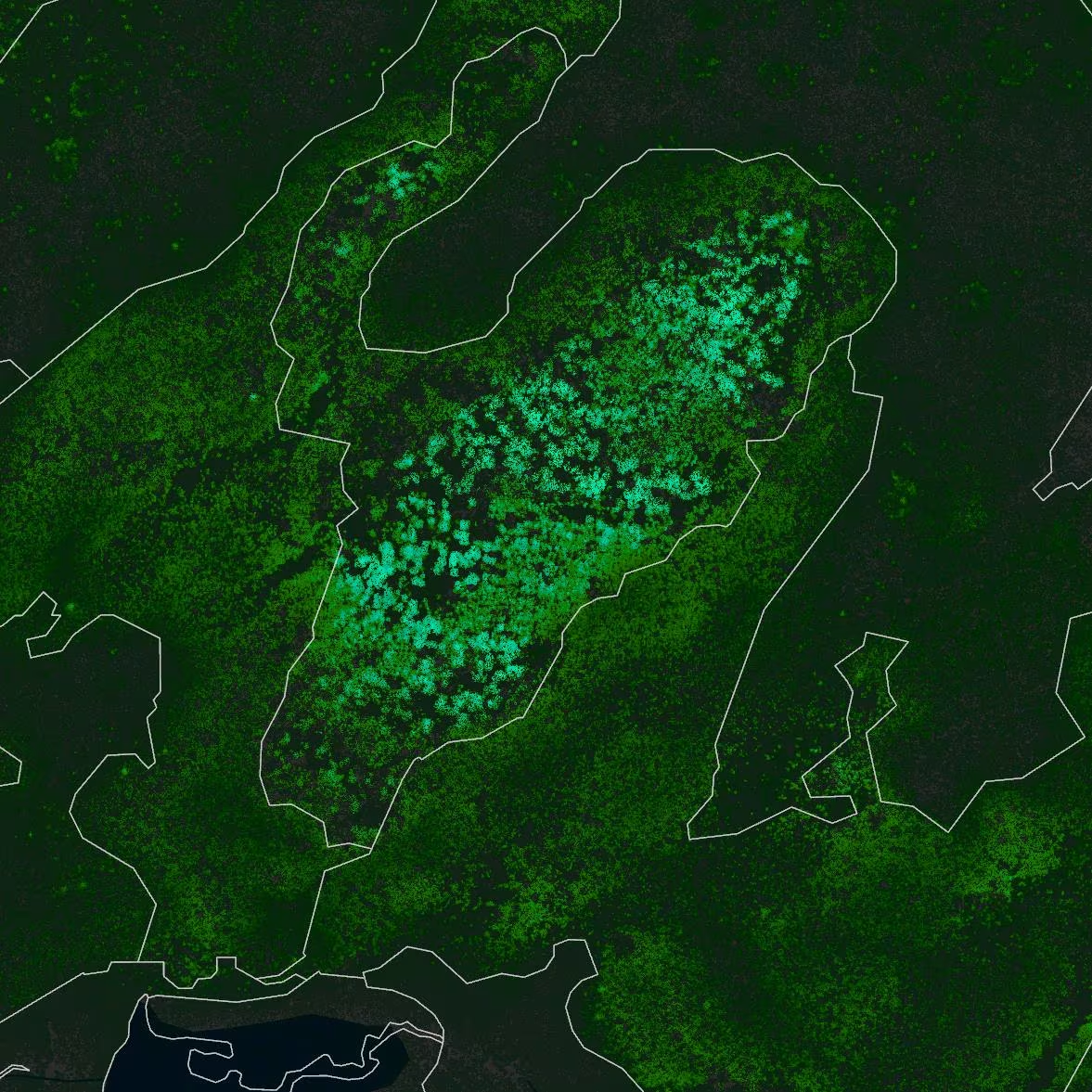
2. Fuel ID Integration
Where the vegetation picture needs to extend to detailed fuels, Forsite integrates its proprietary Fuel ID tool into utility risk assessments. Fuel ID produces current, validated forest fuel maps from LiDAR and satellite imagery, including high-resolution (10m) mapping where applicable. This supports precise analysis of fuel loads, ignition and spread potential, and associated hazards along infrastructure corridors, building on the vegetation intelligence captured through Tree ID.
3. Wildfire Risk Management Plans
Forsite develops comprehensive Wildfire Risk Management Plans tailored to each client's infrastructure footprint and operational context. Plans identify, assess, evaluate, and mitigate wildfire risk both to and from utility infrastructure and operations. The goal is plans that are practical, specific, targeted, and measurable, and that can be continuously refined as wildfire science evolves.
4. Wildfire Spread Modeling
Advanced fire modeling simulates wildfire behavior and spread under a range of weather conditions, providing data-driven insights into how fire could move across the landscape surrounding utility assets. This supports both long-term strategic planning and emergency response preparedness.
5. Situational Awareness Tools
Forsite builds situational awareness tools that integrate daily fire weather and fuel conditions, enabling utility clients to make informed, science-based operational decisions throughout fire season. These tools translate complex data into actionable intelligence for operations teams.
Results & Deliverables
Forsite delivers rigorous, science-backed solutions that support utility risk mitigation and operational decision-making across two timeframes:
Strategic (Long-Term):
- Comprehensive written Wildfire Risk Management Plans with site-specific recommendations
- High-resolution fuel and vegetation hazard maps along infrastructure corridors
- Wildfire spread modeling outputs illustrating fire behavior under various scenarios
- Climate scenario analysis integrating historic weather data and predicted future conditions
Operational (Real-Time):
- Daily wildfire risk updates during fire season to support informed, timely decisions
- Situational awareness tools customized to the client's infrastructure and operational needs
- A major AB transmission operator utilizes RiskView to predict where a PSPS event will occur, and for how long
The Broader Value: From Risk to Resilience
Wildfire risk management for utilities isn't just about protecting physical assets. It's about ensuring the continuity of services that communities depend on, maintaining regulatory compliance, and demonstrating due diligence to insurers, regulators, and the public. Forsite's integrated approach helps utility clients build lasting operational resilience: a systematic, science-based program that grows more effective over time as data accumulates, models are refined, and teams become more practiced in applying risk intelligence to real decisions.
Conclusion
Wildfire risk to utility infrastructure is a growing reality across fire-prone regions worldwide. Forsite's combination of remote sensing technology, vegetation analysis, advanced fire modeling, and practical risk management planning gives utility providers the tools they need to understand their exposure, protect their assets, and keep the lights on, even as fire seasons grow longer and more intense.
Want to learn how Forsite can strengthen your utility's wildfire risk management program?
FAQ
#1: What does a Forsite utility wildfire risk assessment include?
Answer: A full assessment typically combines a desktop analysis of local fuels, weather patterns, topography, and fire history with on-site field validation. It incorporates wildfire spread modeling under various weather scenarios and results in a written Wildfire Risk Management Plan with practical, prioritized recommendations tailored to the client's infrastructure.
#2: How does Forsite assess vegetation risk along utility corridors?
Forsite assesses vegetation along utility corridors with its Tree ID tool, which uses machine learning and LiDAR remote sensing to identify and attribute individual trees by species, height, and canopy structure, then locate each one relative to infrastructure. That detail shows what is growing where, so vegetation management can target the spans that need it most. Where the assessment needs to extend to fuels, Forsite adds its Fuel ID tool, which maps forest fuel loads from LiDAR and satellite imagery at a resolution of 10m, far exceeding the detail available from national datasets.
#3: What is a situational awareness tool and how does it help during fire season?
Answer: Forsite's situational awareness tools integrate daily fire weather data and current fuel conditions into a platform tailored to the client's infrastructure footprint. This allows operations teams to make informed, science-based decisions in real time, for example, adjusting field operations, pre-positioning resources, or implementing protocols when risk thresholds are reached.
#4: Can wildfire risk management plans be updated over time?
Answer: Yes, and they should be. Forsite designs plans to be continuously refined as new data becomes available, wildfire science evolves, and the landscape changes due to disturbance, harvesting, or climate shifts. This ensures the plan remains a living, relevant tool rather than a static document.
#5: Does Forsite only work with large utility providers?
Answer: Forsite works with a range of utility clients from major transmission operators to regional distribution utilities. Our assessments are scalable: the same rigorous methodology that supports province-wide risk programs can be adapted to a focused corridor assessment for a smaller operator. If you’re unsure whether your organization’s scope is fit, we encourage you to reach out. We’re happy to discuss what a right-sized program could look like.
#6: How does wildfire risk management support regulatory and insurance requirements?
Answer: A documented, science-based Wildfire Risk Management Plan demonstrates due diligence to regulators, insurers, and other stakeholders. As wildfire risk disclosure requirements evolve in various jurisdictions, having a rigorous, regularly updated risk management program in place positions utility providers to meet emerging obligations proactively.
In British Columbia, the BC Utilities Commission (BCUC) and provincial wildfire legislation increasingly expect utility operators to demonstrate proactive risk management. In Alberta, the Alberta Utilities Commission (AUC) and the province’s FireSmart framework similarly underscore the importance of documented risk programs. In Nova Scotia, evolving climate disclosure expectations and insurer requirements are raising the bar for risk documentation. Forsite’s plans are structured to support these requirements and function as evidence of a systematic, science-based approach to due diligence.
.avif)
.png)