.svg)
Insurance
Property-Level Wildfire and Wind Intelligence for Underwriting, Pricing, and Claims
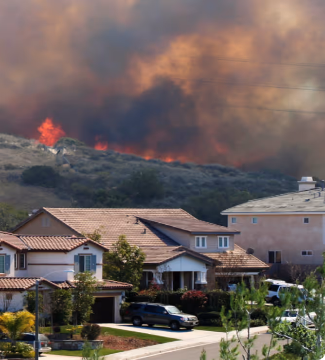
Property and casualty carriers writing in wildfire-exposed markets need parcel-level precision; not coarse geographic proxies. Forsite delivers LiDAR-derived structure measurements, fuels intelligence, and dynamic fire behavior modeling to improve rate adequacy, refine modeled PML accuracy, and accelerate claims validation.
Proven in the Field
Property-Level Risk Analytics That Improve Loss Ratios
Most property risk models rely on 2D imagery that doesn't measure height, structure, or topography — producing uncertainty in vegetation clearance, roof geometry, and wall height. Forsite replaces broad rating-cell assumptions with parcel-level wildfire exposure: updated risk metrics and post-event severity mapping that reduce uncertainty, lowers capital costs, and sharpens pricing accuracy.
Key performance outcomes observed in Florida portfolios
3–8% reduction in modeled PML
1–3% rate adequacy improvement
2–4 point loss ratio stabilization
Higher-confidence reinsurance positioning
Data quality
highlights
Dynamic risk metrics
50 cm to 10 m fuels and fire treat maps
Post-event data collection
Single-tree resolution risk metrics
LiDAR-Derived Structure and
Parcel Intelligence for Underwriting
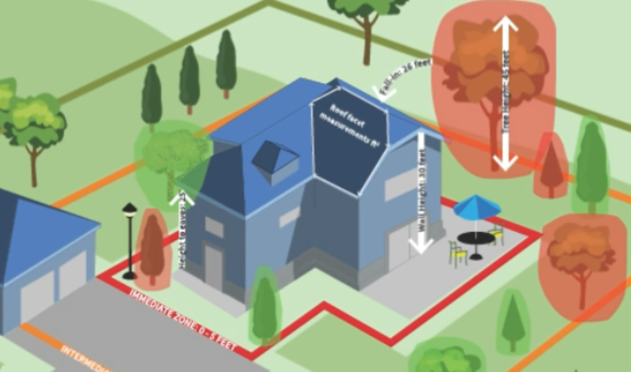
Traditional 2D property data solutions underestimate building geometry and defensible space due to missing elevation and vegetation accuracy. LiDAR solves this by replacing estimates with measurements.
Why LiDAR Matters
True 3D measurement vs 2D imagery
Unmatched elevation accuracy for roof geometry and wall height
Canopy penetration — accurate footprints even in heavy vegetation
Precise structure-to-fuel clearance
Insurance Value
Daily fire weather, fuels, and behavior modeling feed situational awareness to support ignition-risk decisions and emergency response.
Improved risk selection and pricing
Better defensible space scoring — no more estimation
Enhanced wildfire modeling inputs
More accurate flood and wind loss models
Better claim validation and fraud identification
Improved probable maximum loss (PML) calculations
Underwriting and Portfolio Analytics
Use parcel-adjacent fuels, vegetation, slope, and WUI exposure indicators to differentiate risks inside the same rating territory, improving selection and reducing premium leakage.
Underwriting inputs include:
Parcel-level fuels and vegetation context
Structure-to-fuel separation
WUI classification and slope exposure
Scenario loss drivers — FireView™ modeling
.avif)
Event Monitoring and Claims Intelligence
Active fire detections and progressive burn footprints accelerate claims verification and fraud reduction through geospatial verification.
Event intelligence includes:
Near-real-time detection alerts
Progressive damage footprints
Post-event change detection
Faster severity validation for adjusters
Solutions Mapped to Insurance Workflows.
Forsite Exchange
Geospatial data products library designed to address current and future risk by providing continuous, accurate, and actionable information.
Forest health
Fire preparedness, risk, and burn severity
Rural and urban community safety
Transportation mapping
Utility risk assessments
Resource budgeting
RiskView™
Operational dashboards for event awareness.
Vegetation baselines where needed — powered by ForestView®
Fuels and behavioranalytics for risk and events — powered by FireView™
Alerts and thresholds
Frequently Asked Questions
Do you provide parcel-level insights?
Yes, fuels and vegetation context and exposure indicators can be aligned to parcels and portfolios.
Can we integrate via API?
Yes, dashboards and APIs are available for risk and event feeds.
At what resolution is the data collected and processed?
<6-inch resolution.
What is LiDAR and how is it different from satellite imagery for structure and parcel intelligence?
LiDAR (3D) lets you actually measure elevation vs 2D imagery where you are estimating elevation (true 3D vs 2D interpolation for elevation measurements).
How does LiDAR data plug into the CAT models we already use?
Through APIs which expose and link property elements similar to any other property centric database.
.avif)
Ready to Refine Wildfire and Wind Risk and Claims?
Let's connect geospatial analytics to your underwriting and claims operations.