.svg)
Forest Operations — Complete Forest and Land Management
Field-Ready Forest Operations That Deliver Safe, Efficient, and Compliant Results
Forestry success happens on the ground. Our operational teams combine timber development and harvesting expertise, field operations, full-phase stand establishment, wildfire risk mitigation and restoration, and LiDAR and GIS-enabled planning to execute projects safely, efficiently, and in full alignment with regulatory requirements. From block and road design to reforestation and wildfire mitigation treatments, we ensure work is done right — the first time.

why organizations trust us
Proven Operational Scale and Expertise
Our long history of operational delivery ensures reliable execution across diverse terrain and regulatory environments.
1M
ACRES
Land base with inventory plots measured supporting prescriptions
1.1-3M
sEEDING ADMINISTERED ANNUALLY
9 provinces and 29 states
Projects completed
Heritage
Decades of field delivery including cutblock and road layout, cruising and appraisals, assessments and prescriptions, steep slope development, timber sale administration, and operational supervision across the western US and Canada.
Timber Development
We use highly detailed data to plan efficiently and reduce safety exposures. We bring integrated expertise to ensure operations are safe, economical, and compliant.
Full cutblock and road layout, including terrain, hydrology, boundary, reserves, and cable and steep-slope feasibility assessments
Operational planning with LiDAR enables efficient design and reduces safety exposure
Integrated cruising, appraisal, and timber sale administration to align value, pricing, and compliance
Regeneration Success Defines Long-Term Value
We manage all phases of silviculture/ reforestation and stand establishment, and provide single project to full program management.
We Deliver
Liability management and reforestation supervision including planting implementation programs
Reforestation and planting supervision and management
End-to-end program management for government and private clients
Best management practices for rehabilitating stands post-wildfire
Wildlife, Water and Soils
Healthy wildlife habitat, stable soils, and reliable water resources are essential components of land stewardship. Our team provides soil-erosion assessment, road layout expertise, and conservation-focused field analysis to help protect ecological values while supporting long-term operational objectives.
Soil-erosion assessment, mitigation planning, and road-layout expertise
Integrated cruising, appraisal, and timber sale administration to align value, pricing, and compliance
Key Features and Benefits
Operational execution aligned with safety, regulatory requirements, and value optimization.
.png)
customers testimonials
What Our Clients Say

Canfor currently manages a large operating area across British Columbia and Alberta. We have a longstanding contract with Forsite and their Operational Planning Team, to produce highly accurate block and road designs using LiDAR. These designs have carried cost savings effects on multiple phases of Canfor's business, from Timber Development, all the way to Harvesting Operations. Through a collaborative process with Canfor Planning Foresters, Forsite has produced timely volume deliverables critical to the Woodlands operations and business.
As fibre supply is more challenging across the landscape today, Canfor is operating on steeper slopes and pushing operations upslope within our current operating areas. As such, Canfor has relied on Forsite and their experience to provide Level 2 geometric road designs, within the scope of practice for Forestry, to accompany steep slope road sections. This has provided Canfor with insight into earth works, pinch points and areas where extreme care and attention are required during the planning and construction phases of development. Forsite's guidance and professional road designs in this complex area of Forestry have provided Canfor with a quality product and certainty with steep road locations.
read morecase study
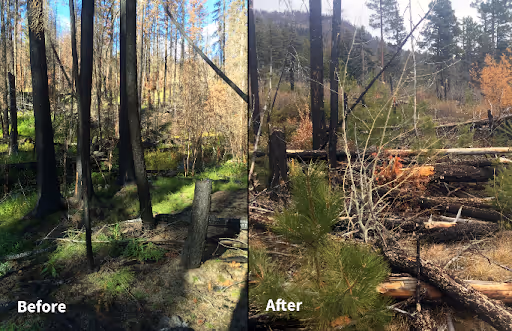
Reforestation and Stand Establishment Post-Wildfire in Elephant Hills
Learn how Forsite supported post-wildfire reforestation after the 2017 Elephant Hills Wildfire using silviculture planning, planting strategy, and the Natural Regeneration Matrix.
Read more
Frequently Asked Questions
What operational services do you provide?
We deliver planning, block and road design, supervision, cruising, and silviculture/reforestation management.
Where do you operate?
We offer field based forest operations from 12 office locations across Canada and the Northwest US (Nelson BC, Kamloops BC, 100 Mile BC, Prince George BC, Fort St John BC, Prince Albert SK, Deep River ON, Fredericton NB, Campbell River BC, Moscow ID, Chewelah WA and Hoquiam WA).
How does LiDAR improve forest operational planning?
LiDAR allows our teams to design roads and cutblock boundaries with a high degree of precision before crews enter the field. Combined with terrain analysis tools, it enables us to locate stream crossings, identify engineering constraints, and account for riparian areas — reducing safety exposures and improving the efficiency of harvest layouts.
What is block and road design, and why does it matter?
Block and road design involves laying out the boundaries, access routes, reserves, and infrastructure for a harvest operation. Optimized designs reduce construction and operational costs, improve value recovery from the timber, and ensure compliance with environmental and regulatory requirements — including hydrology, terrain, and habitat considerations.
What does Forsite's timber development expertise include?
Our team brings full-phase development experience across a wide range of terrain and forest types from flat, dry interior forests to steep-slope, with the full range of harvesting systems and management approaches each requires. We provide services across all phases: planning, reconnaissance, layout, cruising, appraisals, and preparation for submission and approval. Our integrated team means GIS, development and reforestation staff work together making projects like site plans and prescriptions more efficient and informed.
Can Forsite support timberland valuation and private lands management?
Our team provides timberland valuations using cost-based approaches, sophisticated growth and yield models, harvest scheduling, and market analysis. We also offer full private lands and tenure management, from fibre supply due diligence and feasibility through to ongoing operational and program management.
.avif)
Ready to Strengthen Your Operations?
Let's streamline your next operational program.