.svg)
about forsite
North America’s Integrated Geospatial Solutions Company
Forsite (forsitegeo.com) is a geospatial intelligence company operating across Canada and the United States. We bring together aerial LiDAR acquisition, pipeline patrol and inspection, forest management, wildfire risk science, and environmental analytics under one roof, giving utilities, energy operators, land managers, government agencies, and insurers a single partner for the complete intelligence picture their operations depend on.
Formed through the merger of Barr Air Patrol, Barr Geospatial Solutions, Airborne Imaging Inc., Northwest Management Inc., Forcorp Solutions Inc., and Forsite Consultants Ltd. — Forsite combines more than 85 years of aerial heritage, North America's largest independent aerial LiDAR library, and decades of on-the-ground forestry and wildfire expertise into a single integrated platform.
our story
Boots on the Ground. Eyes in the Sky
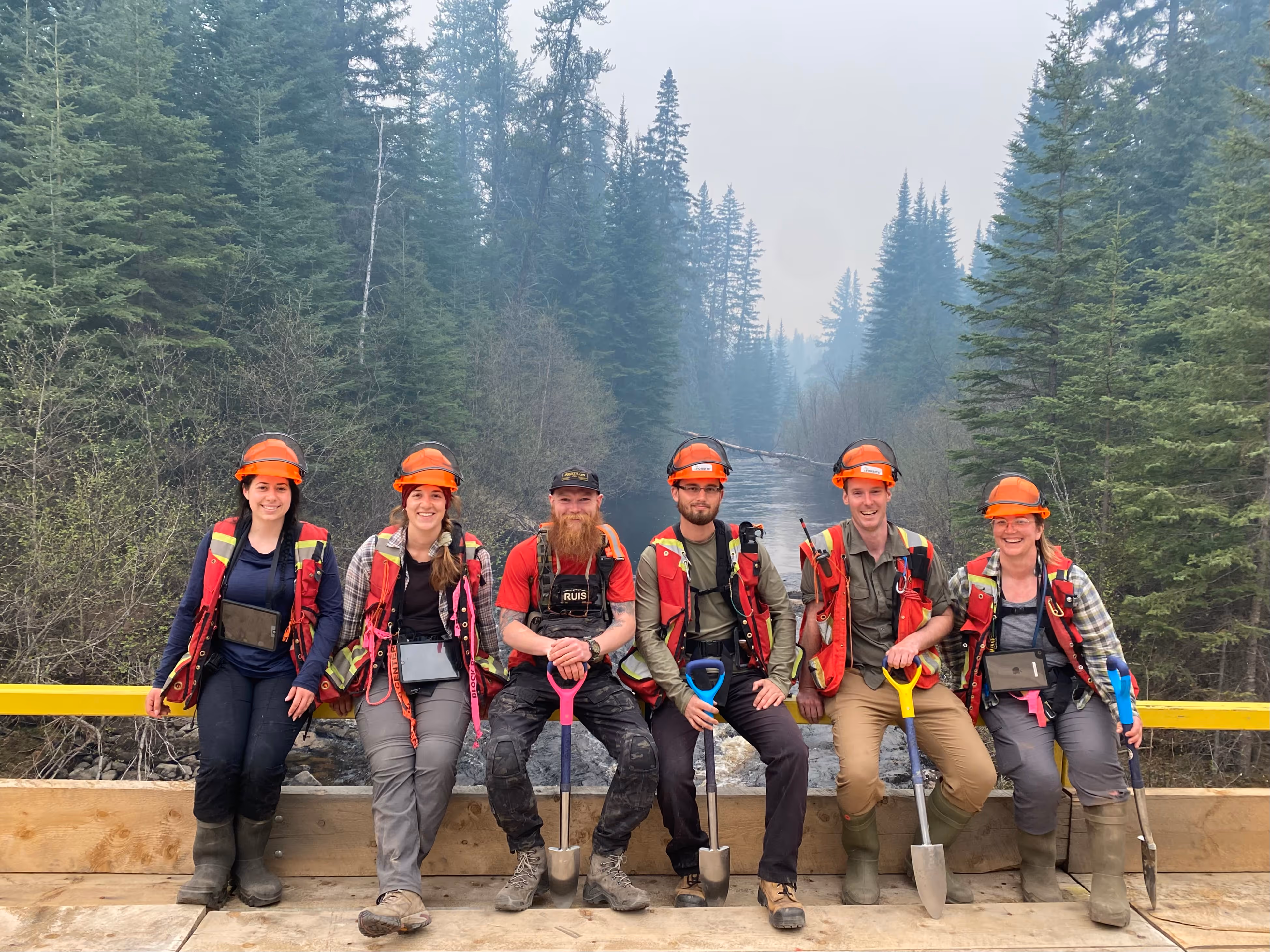
We started in the field. Forsite's roots run deep in two disciplines that most geospatial firms treat separately: the precision of aerial sensing and the judgment of people who have spent careers in demanding terrain. That work took us across the continent, and as the industries we served changed, so did the demands they brought us, shaping how we grew and what we built along the way.
The forest industry adopted LiDAR. Pipeline operators needed more than the standard visual patrol. Utilities began facing wildfire risk on a scale that traditional vegetation management could not address. At each inflection point, Forsite built the capability to respond - adding geospatial specialists, developing proprietary platforms, expanding our operations, and deepening our bench of credentialed experts, planners, analysts, aviators and foresters.
Today, Forsite operates from more than 15 locations across Canada and the United States, with aircraft based at 22 strategic positions across the continental U.S. and forestry and analytics teams serving clients from British Columbia to New Brunswick and from the Pacific Northwest to the southeastern United States.
The best intelligence comes from combining the precision of aerial sensing with the judgment of people who have spent careers in the field.
15+
Office locations across Canada & US
22
Strategic aircraft positions across the continental US
2
Countries with active operations
Decades
Of field experience in
North America's hardest terrain
Where We Come From
Forsite's capabilities are the product of organizations that have been doing this work for generations — not a startup assembling technology for the first time. Each legacy brand brought something irreplaceable to the platform we operate today.
1940 to present
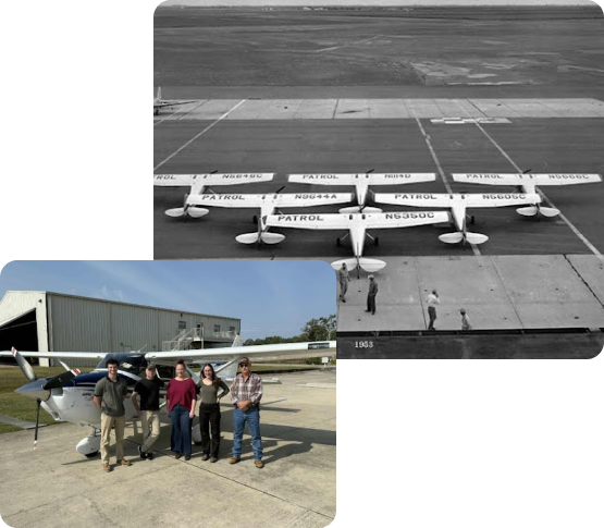
In 1940, F.C. Barr saw what others hadn't: that an aircraft could do what no ground crew could, surveilling hundreds of miles of pipeline corridor in the time it took a truck to reach the end of a single right-of-way. Starting with his own plane and growing steadily through decades of investment in people, aircraft, and safety systems, Barr Air Patrol became one of the most trusted names in pipeline aerial patrol in North America.
That heritage is now Forsite's. Our aerial patrol division operates 45+ aircraft from 22 bases across the continental United States, conducting more than 2.2 million miles of DOT-compliant pipeline right-of-way patrol every year. Airline-qualified pilots with a combined 40,000+ flight hours, operational Safety Management System since 2008, and maintenance facilities in Conroe and Mesquite, Texas ensure every flight meets the standard the industry depends on.
40+ years and growing
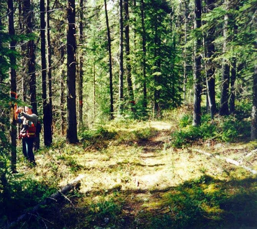
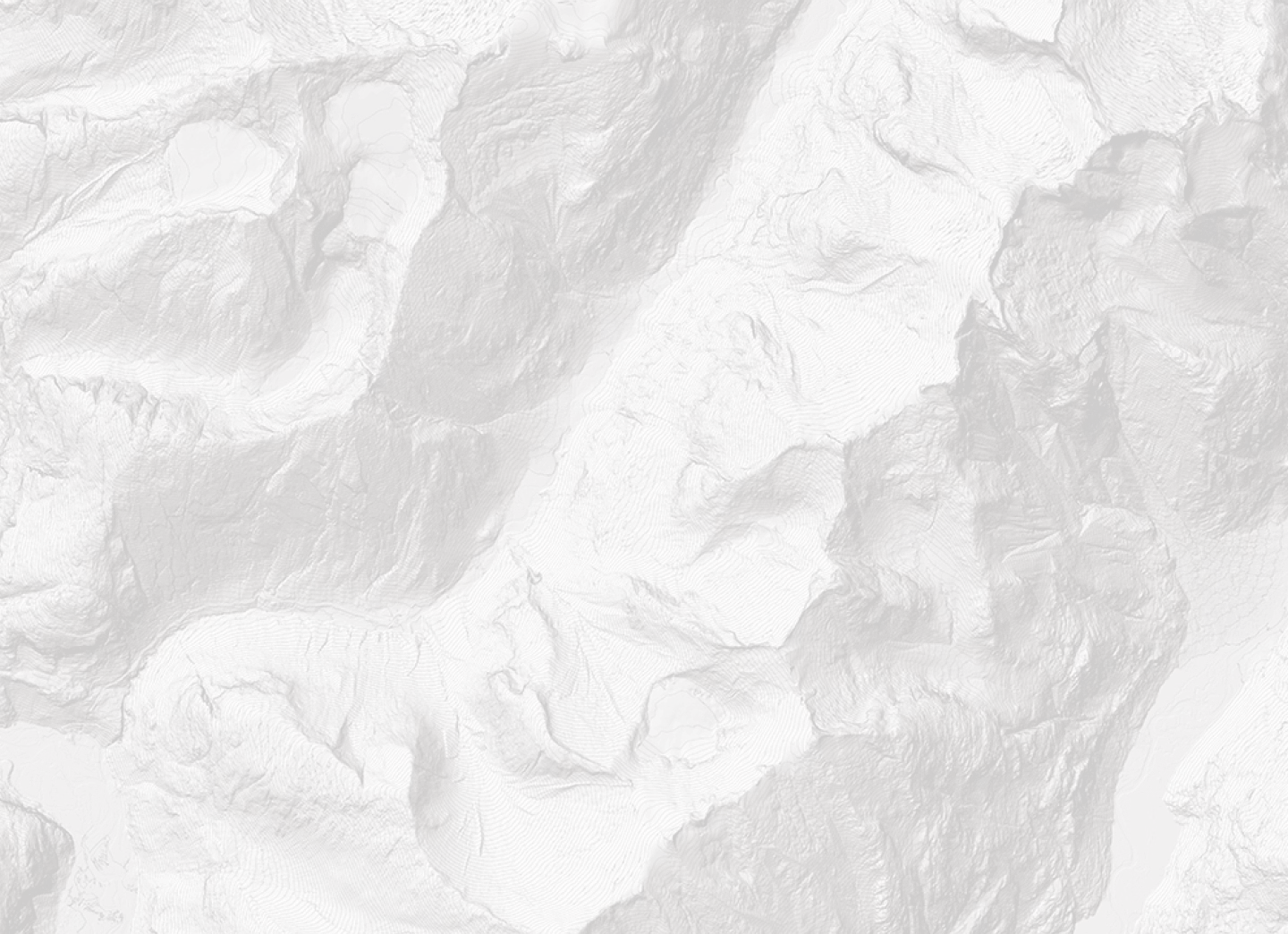
Forsite's forestry roots go back 40 years, beginning in the forests of Idaho, Washington, and British Columbia. When aerial LiDAR made it possible to measure individual trees from the air with accuracy that rivaled field crews, Forsite and Northwest Management Inc. developed the products and methods to make that technology operationally useful — not just technically impressive.
That work is now formalized as ForestView®, Forsite's digital forest inventory platform, and supported by peer-reviewed research published in Forest Science, Remote Sensing, and Forests. Our forestry teams hold Registered Professional Forester (RPF) designations across five Canadian provinces and include Society of American Foresters (SAF) Certified Foresters in the United States. Together, they serve clients ranging from commercial timberland operators and Indigenous Nations to state, provincial and federal government agencies.
Who We Serve
Forsite's clients operate where the stakes are highest: managing critical infrastructure, stewarding natural resources, quantifying risk, and making decisions that affect communities and ecosystems across North America.
They come to us because they need intelligence they can defend. Whether that's a utility mapping vegetation risk along thousands of miles of transmission infrastructure, a pipeline operator documenting compliance with federal patrol requirements, an Indigenous Nation developing a long-term forest management plan, or an insurer modeling wildfire exposure across a western property portfolio — the common thread is a need for accurate, defensible, decision-ready data from a partner with the credentials to stand behind it.
Today, we serve utilities, oil and gas operators, forestry companies and timberland investors, all levels of government, Indigenous Nations, the insurance and reinsurance sector, and mining and environmental management operations.
services & solutions
Our Solutions
Forsite's intelligence platforms are built from the ground up around the operational realities of the industries we serve. They are not off-the-shelf tools adapted to fit — they are the product of decades of field work, scientific research, and direct client feedback.
PatrolView™
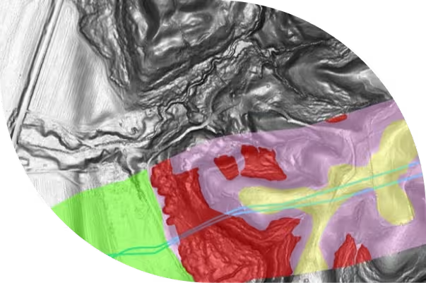
Integrated pipeline patrol, PatrolView oriented imagery, and LiDAR geohazard monitoring: structured for regulatory compliance and built for rapid anomaly detection.
Explore PatrolView™
ForestView®
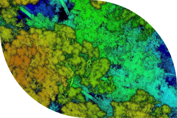
LiDAR-powered digital forest inventory from individual tree metrics to landscape-level planning intelligence. Growth and yield modeling, carbon insights, and GIS-ready deliverables.
Explore ForestView®
FireView™
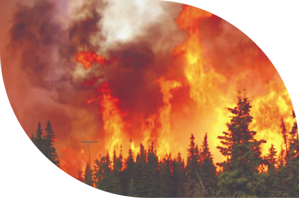
Fuel ID-based wildfire fuels mapping and behavior modeling. 56+ fuel characteristics, validated spread simulations, and exposure analysis for utilities, communities, and insurers.
Explore FireView™
RiskView™
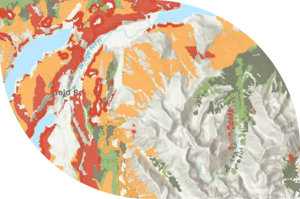
A wildfire risk command center for utility vegetation management teams. Dynamic risk scoring, alerts, EPSS (Enhanced Powerline Safety Settings) and PSPS (Public Safety Power Shutoff) decision support in a single operational dashboard.
Explore RiskView™
Meet the Leadership Team
Forsite's leadership team brings together decades of experience in forestry, geospatial science, aerial operations, wildfire management, and business development. They are the people behind the methodology — many of them have spent careers in the field before moving into the roles they hold today.

CEO
Chris Havern

VP, Sales
Martin Maric

CFO
Alexandre Santos
President, Forestry Business Unit
John Drew

VP, U.S. Growth
Mark Corrao

VP, Forestry Analytics
Cam Brown

VP, Oil & Gas
Kris Covey

Director of Aviation
Greg Reeves
We unlock essential intelligence
through geospatial ingenuity.
vision statement
01
This is not a tagline. It is the standard we hold our work to: that every dataset we collect, every model we run, and every report we deliver unlocks something our clients could not see clearly before. Geospatial ingenuity means we do not stop at technically correct. We push toward operationally useful.
OUR values
02
Five values shape every project, every client relationship, and every hire we make.
Safety
Safety is not just a policy at Forsite — it is the standard by which we measure every operational decision. SAFE Certified since 2007, COR Certified in Alberta and Saskatchewan, and operating under a formal Aerial Safety Management System (SMS) since 2008, we protect our people, our clients, and the communities we fly over.
teamwork
We act as one team, internally and with clients. The best outcomes we have delivered came from genuinely integrated work between our aerial, analytics, and field teams — and from treating our clients as partners in the process, not recipients of a deliverable.
trust
Trust guides every relationship we build. With clients it’s demonstrated through transparency, integrity and consistent delivery. Within our team, trust means mutual respect and accountability—knowing we can rely on one another, step in when support is needed, and stand behind the work we do together.
inNovation
We promote ingenuity and challenge the status quo. ForestView®, FireView™, PatrolView™ and RiskView™ exist because our teams asked whether there was a better way to do the work — and then built it. That instinct is not limited to product development. It applies to every problem we take on.
results
We get it done. Across complex terrain, tight timelines, regulatory constraints, and difficult conditions, Forsite has a track record of delivery because our people are capable, prepared, and committed to the outcome.
Our Commitments
Forsite's commitments to our people, the environment, and the communities we work alongside are not separate from our business — they are part of how we define good work.
DEI: Building a Culture of Ingenuity and Inclusion
Forsite's success is built on the ingenuity and innovation of our employees, who bring a diversity of skills, perspectives, and professional competencies to every challenge we take on. We believe a genuinely inclusive workplace, where people feel valued, respected, and fully able to contribute, makes our work better and our organization stronger.
ESG: Forsite's Sustainability Framework
As a company whose work is inseparable from the health of forests, watersheds, and the communities that depend on them, sustainability is not a framework we apply from the outside. It shapes how we collect data, how we advise clients on land management decisions, and how we run our own operations. We are committed to practices that minimize our environmental impact while delivering the high-quality intelligence our clients need to make responsible decisions.
Indigenous Partnerships: Building Relationships for Long-Term Success
Forsite partners with Indigenous Nations to support Nation-led stewardship of natural landscapes and their resources. We provide expert guidance and technical capacity in land and resource management, governance, and sustainable economic outcomes — always grounded in trust, respect for cultural values, and each Nation's own decision-making processes. Our work advances community-driven forestry, local work opportunities, wildfire management, and environmental planning that reflect Indigenous-defined priorities.
Our team builds collaborative, lasting relationships with Nations — contributing professional expertise and technology-enabled solutions while learning from people who have stewarded natural landscapes since time immemorial.
Commitment to Data Sovereignty
Our work with Nations is guided by each community’s protocols, timelines, and priorities. We uphold data sovereignty and work closely with every Nation to ensure their information is protected and used in ways that align with their values and governance structures, ensuring protection of sensitive cultural and environmental information.
Our state-of-the-art data security systems and practices support:
Nation-controlled data ownership and access
Nation-specific data storage requirements
Alignment with OCAP® principles
Nation specific data sovereignty frameworks
Transparent data practices and clear data-use agreements
We are committed to ensuring that Indigenous Nations maintain full authority over their data and that our work strengthens, rather than replaces, community knowledge systems and decision-making.
Join the Forsite Team
Forsite is built by people who take their work seriously and find meaning in it. Whether you are a forester with years of field experience, a geospatial analyst looking for problems worth solving, a pilot who wants to fly for a company that treats safety as a core value, or a data scientist ready to work at the intersection of ecology and technology — there is a place for that here.
.avif)
Ready to Work With Us?
Whether you are managing risk across a transmission network, planning a forest inventory, or building a wildfire resilience program for your community — Forsite has the expertise, the tools, and the track record to be the partner you need.