.svg)
LiDAR and Imagery
Precise Aerial LiDAR and Imagery, from Acquisition to Analytics
Forsite provides precise, scalable geospatial data across North America — from wide-area basemaps to corridor-grade detail. Our integrated fleet, sensors, and processing pipelines enable rapid data collection with defensible accuracy, delivering industry-ready products for infrastructure, natural resources, and environmental applications.

Capacity, Accuracy, and Deliverables
With one of North America's largest aerial fleets, a broad range of LiDAR and imagery sensors, and proven QA/QC workflows, we collect, process, and deliver geospatial data and derivatives at scale and with confidence.
Benefits
Large area and corridor acquisition with high-throughput processing for fast turnaround
High-density LiDAR and co-collected imagery for precise mapping, modeling, and asset analysis
Reduce cost by leveraging one of North America's largest private LiDAR libraries — Forsite Exchange
Flexible, fit-for-purpose outputs — from orthos and DEMs to vegetation, hazards, and 3D products
why organizations trust us
Independent Leader in Aerial LiDAR Acquisition
Decades of collection experience, industry-leading fleet size, and consistently delivered large-area programs.
1.9M
sq mi
LiDAR collected since 2004
45
aircraft / 25+ sensors
LiDAR and imagery sensors
100,000
sq mi/year
Delivered annually through high-capacity processing
2.2M
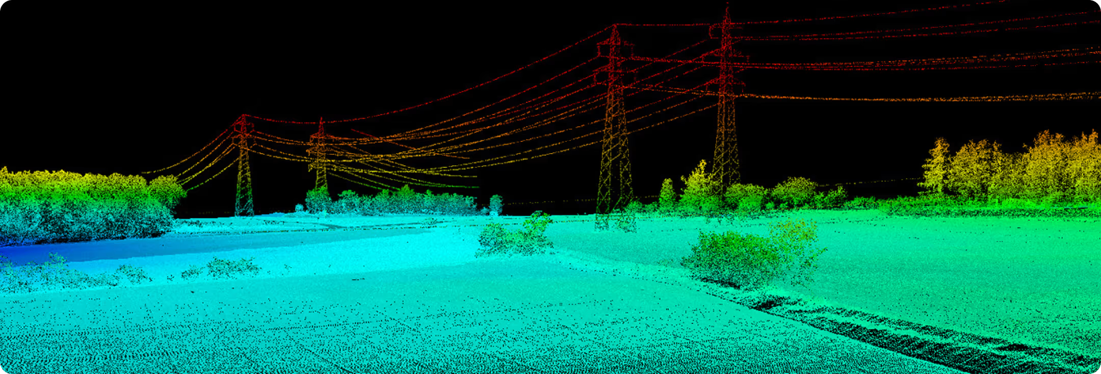
miles of corridor inspection annually — critical infrastructure
.svg)
LiDAR Collection Planned for Your Terrain and Density Needs
Sensor selection, flight planning, and co-collection options ensure accuracy, efficiency, and cost control across diverse terrain and project types.
Airborne LiDAR platforms with integrated cameras for simultaneous LiDAR and imagery capture
Ground control networks and survey for calibration, QA/QC, and defensible accuracy reporting
Multi-industry deliverables: utilities, natural resources, engineering, oil and gas, forestry, and government
High-Resolution Imagery and Derivative Products
Ortho, stereo, oblique, and 3D products that support design, change detection, assessments, and emergency response.
Large-format 4-band cameras for detailed wide-area collection
Nadir and oblique and corridor collection for assets and linear infrastructure
Analytics and post-processing convert data into derivative products for actionable intelligence
Forsite Exchange
Exchange is a high-resolution geospatial data products library accessible to everyone. It's designed to address current and future management objectives and mitigation efforts by providing continuous, accurate, and actionable information across entire cities, counties, provinces, and landscapes.
Contiguous Lidar Collections
(up to 20 ppm)Field verified terrain, vegetation and forestry insights
Fire Exposure & Mitigation Mapping
Information founded in field data and 3rd party validation
Models are agency compatible and academically sound
Key Features and Benefits
From acquisition to analytics. A complete, end-to-end geospatial delivery backed by one of the continent's largest fleets and libraries.
Empowering Your Team
LiDAR Acquisition
Riegl sensors, co-collection, and control networks.
Learn More
Imagery Acquisition
Large-format 4-band cameras and corridor options.
Learn More
Derivative Products
DEMs, hill shades, planimetrics and topo, 3D models.
Learn More
Exchange Library Coverage
Existing LiDAR coverage available for purchase where it fits your area of interest.
Learn More
Frequently Asked Questions
Do you provide ground control?
Yes, we establish control networks and survey for calibration and QA.
Can you co-collect imagery with LiDAR?
Yes, many sensors integrate cameras for simultaneous capture.
What deliverables do you support?
From point clouds to DEMs, contours, orthos, planimetrics, and 3D models.
Do you have existing data?
Yes, we maintain one of the largest private LiDAR libraries in North America.
.avif)
Planning a LiDAR or Imagery Project?
We'll scope density, coverage, deliverables, and timelines to meet your goals.