.svg)
The Pipeline Resolution Gap: Why Satellite Alone Can't Catch What Matters Most
Satellite monitoring has a real role in pipeline integrity programs. A single tasking can screen hundreds of miles of right-of-way for broad environmental change, in terrain a ground crew would take days to cover, and it reaches remote regions aircraft can't easily access on a routine basis.
A more useful question for most operators isn't satellite versus aerial, it's where each earns its place in a monitoring program. Satellite is well suited to broad-area screening and trend detection across a network. Aerial inspection adds the resolution, rapid targeted response, and richer context needed to investigate a flagged threat and act on it with confidence. The value isn't just in collecting imagery. It's turning that imagery into a decision and dispatching a ground crew only when there's a confirmed threat worth their time.
What satellite does well, and where the coverage math gets expensive
Frequent revisit imagery, continental scale, and no aviation exposure are real advantages, and satellite has earned a place in operators' monitoring toolkits for exactly those reasons. But observation frequency doesn't always translate into actionable intelligence, and the economics of tasking a satellite for a linear asset are worth a closer look.
Most commercial satellite tasking is sold in minimum blocks of around 10 square miles. A pipeline right-of-way is typically 50 to 100 feet wide, so operators end up paying for a large area of farmland, forest, or open range to capture a thin strip of actual asset in the frame. Aerial patrol is tasked to the line instead. Every mile flown is right-of-way, so coverage maps one-to-one to the asset being managed, at roughly a tenth of the cost per mile and, depending on sensor and altitude, meaningfully higher resolution. Lower cost and higher resolution rarely come together. On a linear asset like a pipeline, that's the trade aerial makes possible.
Encroachment is where resolution matters most
Third-party excavation damage is the leading cause of serious pipeline incidents in North America. PHMSA data attributes roughly a fifth of all significant incidents on hazardous liquid and gas transmission pipelines over the past two decades to excavation damage, and more than a third of incidents involving fatality or hospitalization. A backhoe on the right-of-way isn't a trend to track over a monitoring cycle. It's an active threat with a clock running, and the only response that matters is one that reaches the right-of-way team before the bucket hits the pipe.
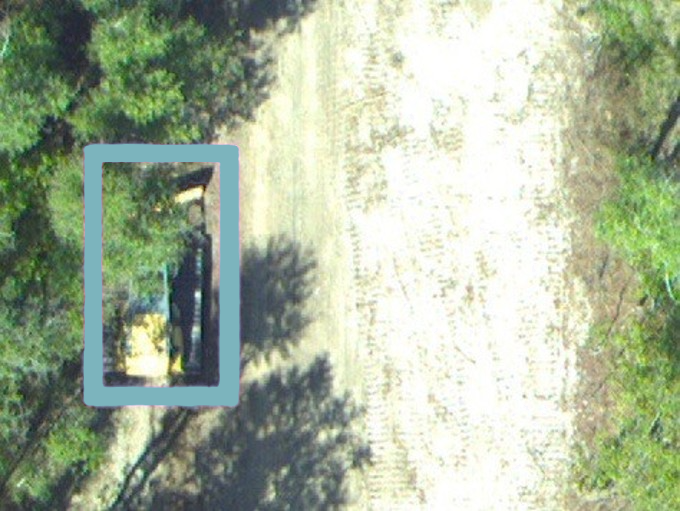
This is the scenario where the resolution gap is the whole story, for the optical imagery most high-resolution satellite tasking still relies on. Some satellite operators also fly synthetic aperture radar, which can detect that an object is present by its radar reflection, but can't identify what it is or gauge its size, so it can't classify the threat well enough to act on. At around 50 cm, a common standard for widely available high-resolution satellite imagery, a backhoe working under partial tree canopy blurs into shadow and surrounding vegetation. It's effectively invisible until the disturbance it leaves behind is large enough for a wide-area sensor to register, often well after the fact. The same scene flown at low altitude with high-resolution optical sensors resolves clearly enough to classify the equipment, flag it as an excavator, and route it to a right-of-way team the same day, with the exact GPS location attached. That's the difference between confirming damage occurred and preventing it. That resolution advantage extends to identification, not just detection. Forsite's PatrolViewTM can resolve a company logo on a truck, telling a known, ticketed contractor apart from a digger not authorized to be there.
Satellite screening does its job well on large, sustained changes: new construction, a cleared pad site, a shifted access road. It's built for exactly that kind of pattern over a wide area. But the leading cause of pipeline failure is a single piece of equipment, in one spot, for a matter of hours, and that's a resolution problem before it's a scheduling one. A weekly aerial patrol and a weekly satellite tasking cover the same interval, but only one of them resolves the equipment clearly enough to classify it and route it to a right-of-way team the moment it's spotted. Aerial patrol can also fly on demand, adding a targeted flight outside the regular schedule when something needs a closer look, in a way fixed satellite tasking generally can't match. Optical satellite imagery is also weather-dependent: cloud cover can delay a pass, and nothing gets collected at night. While SAR-equipped satellites do get through cloud cover and, depending on the radar band, some vegetation, they carry the same detect-versus-classify limit described above.
Leak detection is where the two methods separate the most
Satellite-based methane monitoring has made real progress. Systems like GHGSat's satellite constellation can detect plumes down to roughly 100 kilograms per hour, across an observation footprint of roughly 12 kilometers across per pass. That's a legitimate tool for finding large emitters across a wide territory. But detection thresholds and revisit timing mean small or medium releases, exactly the kind operators want to catch early, can fall below what a satellite pass resolves. GHGSat's own aerial service uses the same underlying sensor technology flown at low altitude specifically to close that gap, because a lower-altitude platform detects smaller leaks and can localize the source more precisely than the satellite version of the same instrument.
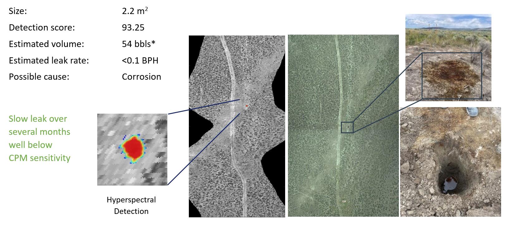
The logic of resolution and sensitivity extends beyond methane. Forsite's PatrolView carries hyperspectral sensing capable of resolving liquid hydrocarbon leaks and seeps at a rate below what control-center monitoring alone typically catches, on every mile flown. It's paired with methane detection that adds plume mapping and wind context for comparison flight over flight. That same principle extends throughout the platform: leak detection, threat classification, high-resolution imagery, and DOT/PHMSA compliance reporting all come down to how close and how sharp the sensor can get. PatrolView runs all of it from the same flights, built on more than 85 years of aerial patrol experience and 2.2 million miles of DOT-mandated patrol flown annually.
PatrolView’s leak detection, powered in part by sensing technology from partner Flyscan Systems Inc., has the field results to back it up. “We detected an 11-liter liquid leak of oil, and a natural gas leak so small, from a pig launcher, that the ground crew had to use soapy water to find it, with bubbles,” says Flyscan CEO Eric Bergeron. “No way those two leaks could have been found from space, yet they were detected by our system.”
The two methods work best together
None of this argues for retiring a satellite tasking contract that's already doing useful work for network-wide screening. PatrolView is sensor-agnostic, and satellite imagery is already a supported input alongside aerial and ground data. For most operators, the practical answer is layered: satellite for continuous, wide-area trend detection, and aerial where a threat needs to be confirmed, classified, and acted on with confidence, whether that's a piece of equipment on the right-of-way, a seep too subtle for a wide-area sensor, or a compliance record that needs to hold up to a PHMSA audit. Choosing where to fly and where to task from orbit is a cost and coverage decision made corridor by corridor.
---
* PatrolViewTM is Forsite's unified aerial intelligence platform for pipeline operations, combining threat detection, leak monitoring, high-resolution imagery, vegetation planning, and DOT compliance into a single service. Learn more at https://forsitegeo.com/patrolview.*
.avif)