.svg)
RiskView™
RiskView™ — A Risk Monitoring Command Center for Utility Wildfire Operations
Unifies weather, assets, and wildfire risk modeling to shift from reactive response to proactive risk management, with dynamic risk scoring, alerts, and decision support for O&M, blocking reclosers, EPSS and PSPS, and emergency operations.
.svg)
.png)
Proven in the Field
Situational Awareness
Built for Utilities
RiskView™ combines advanced fire behavior modeling, weather intelligence, and asset mapping to produce dynamic risk scores and real-time alerts to help teams reduce ignition risk, minimize outages, and optimize investments.
Benefits
Dynamic risk scoring and dashboards
Integrated fuels, weather, and asset layers
Decision support for EPSS, PSPS, blocking reclosers and field operations
NOTES
Built by wildfire and utility specialists
Supports proactive, intelligence-driven risk management
Seamless integration with advanced vegetation analytics
Features
Key Product Features
From data to decisions during fire season and beyond.
Combines fire weather, assets, wildfire modeling, and consequences to continuously update operational risk and support real-time decision-making.
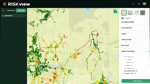
Map-based risk visualization by asset class
Circuit and asset prioritization based on exposure and thresholds
Configurable, multi-day forecast horizons
.png)
Real-time alerts, thresholds, and routing to align operators and crews.
Configurable thresholds
Crew notifications
Compliance audit reports
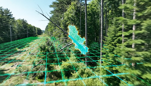
Use individual-tree metrics and encroachment codes to plan work by risk and consequence.
Species Identification
Growth and health
Span prioritization
Provides situational awareness and actionable decision support for wildfire risk – from potential ignitions to active wildfires threatening infrastructure – enabling informed operational decisions
Hourly EPSS, PSPS, and blocking recloser insights
Ignition potential and fire growth
Utility-specific thresholds and configurations
Audit trails and defensible decision history
O&M alignment
Capital planning inputs (mitigation prioritization)
PRIMARY USE CASES
Where RiskView™ Drives Better Outcomes.
.png)
Daily Fire-Season Operations
Situational awareness with evolving scores and alerts.
Threshold-based actions
Crew dispatch
Patrol Focus
%201.png)
Vegetation Management
Plan cycles using risk, species, growth, and health analytics.
Utility-specific intrusion codes
Fast-grower prediction and alert
Treatment ROI
%201.png)
Wildfire Mitigation Planning
Access comprehensive assessments of where your network carries the highest risk.
Quantify risk from (ignition potential) and risk to (wildfire exposure) across assets
Identify and prioritize highest-risk areas
Assess asset health and vulnerability
Evaluate impacts on consumers, surrounding communities and values at risk
%201.png)
Capital and Compliance
Support defensible mitigation programs and regulatory reporting with transparent modeling, thresholds, operational context, and expert witness support as needed.
Justify program spend using risk-based prioritization
Provide regulator-ready reporting with transparent assumptions and methodology
Support compliance with auditable outputs and decision history
After-Action and Learning
Codify lessons and refine thresholds each season.
Decision logs
Past-season review
Continuous improvement with historic data
Frequently Asked Questions
What makes RiskView™ different?
It integrates weather, assets, and wildfire risk modeling for dynamic- real-time scoring – moving beyond static maps to support operational decisions.
Can it integrate our data?
Yes, ESRI, OMS, ADMS, and standard enterprise integrations are supported.
How does it support EPSS and PSPS?
By providing configurable thresholds, alerts, decision logs, and context layers that guide targeted electrical settings, shutoffs and communications.
.avif)
Ready to Control Your Wildfire Risk?
Let's connect RiskView™ to your assets, data, and seasonal workflows.