.svg)
PatrolView™
PatrolView™ — Aerial Patrol, AI Threat Detection, Leak Detection, and LiDAR for ROW Integrity
Forsite operates the industry's largest dedicated pipeline patrol network, modernizing ROW integrity from detection through compliance. Our AI-powered network threat detection catches encroachments before they become line strikes, while continuous methane and liquid leak detection fly on existing patrol flights. By integrating LiDAR geohazard monitoring and vegetation management, Forsite gives operators full transparency across their entire system from a single operator.
.svg)
KEY product FEATURES
Comprehensive ROW Intelligence from a Single Operator
Forsite pairs the industry's largest dedicated pipeline patrol network with AI-powered threat detection, continuous leak monitoring, ESRI-integrated compliance apps, and LiDAR geohazard programs — giving operators complete intelligence across their ROW.
2.2M
MILES/YEAR
ROW patrolled annually across the United States and Canada
45
AIRCRAFT
Dedicated to pipeline patrol — largest network of its kind in North America
70
PIPELINE CUSTOMERS
High-density LiDAR collected across North America
Methane and liquid leak detection
Partnered with Flyscan for best-in-class leak detection.
Live across the patrol network today — no additional sorties required.
22
Air base locations across the United States and Canada
Previously known as Barr Air Patrol - now Forsite
KEY product FEATURES
Modular Capabilities — Deploy What You Need Now, Add as Your Program Evolves
Each capability integrates into a single intelligence platform. Start with patrol and compliance then layer in AI threat detection, leak monitoring, and geohazard monitoring as your program matures.
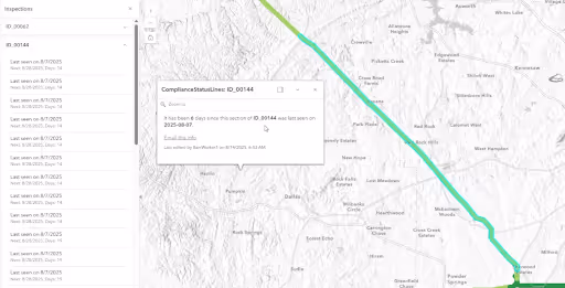
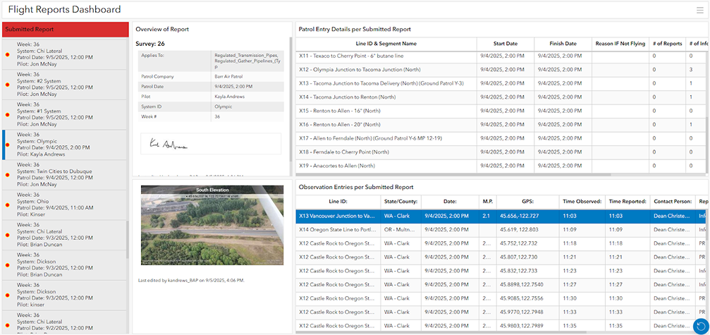
Fully digital, GIS-based patrol reports replace paper-based processes delivering full fleet visibility across both internal and external patrollers. Forsite integrates enhanced metadata to provide historical and real-time flight logs that support regulatory documentation and audit requirements.
DOT-compliant digital patrol records with timestamped proof-of-patrol
Real-time pilot call-out logging with geotagged imagery attached to each event
Variable cadence tracking with no-fly-zone compliance logic built in no-fly-zone compliance logic
Enhanced metadata delivery for historical and real-time fleet visibility
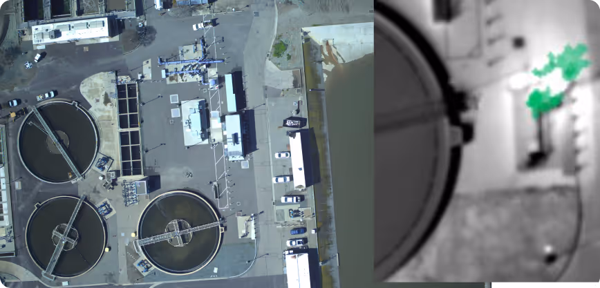
Continuous laser-based methane detection and hyperspectral liquid leak monitoring fly in tandem on existing patrol aircraft — requiring no additional sorties. Detection results flow directly into the Command Center with report-level tracking and change-over-time analysis linked to all pipeline assets.
Laser-based methane detection providing continuous corridor monitoring on every patrol flight
Hyperspectral liquid leak monitoring covering the same ROW corridor as aerial patrol
Asset-linked reporting that connects detection results to specific pipeline segments in the command center
Change-over-time tracking to identify evolving or recurring leak signatures
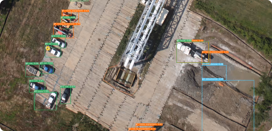
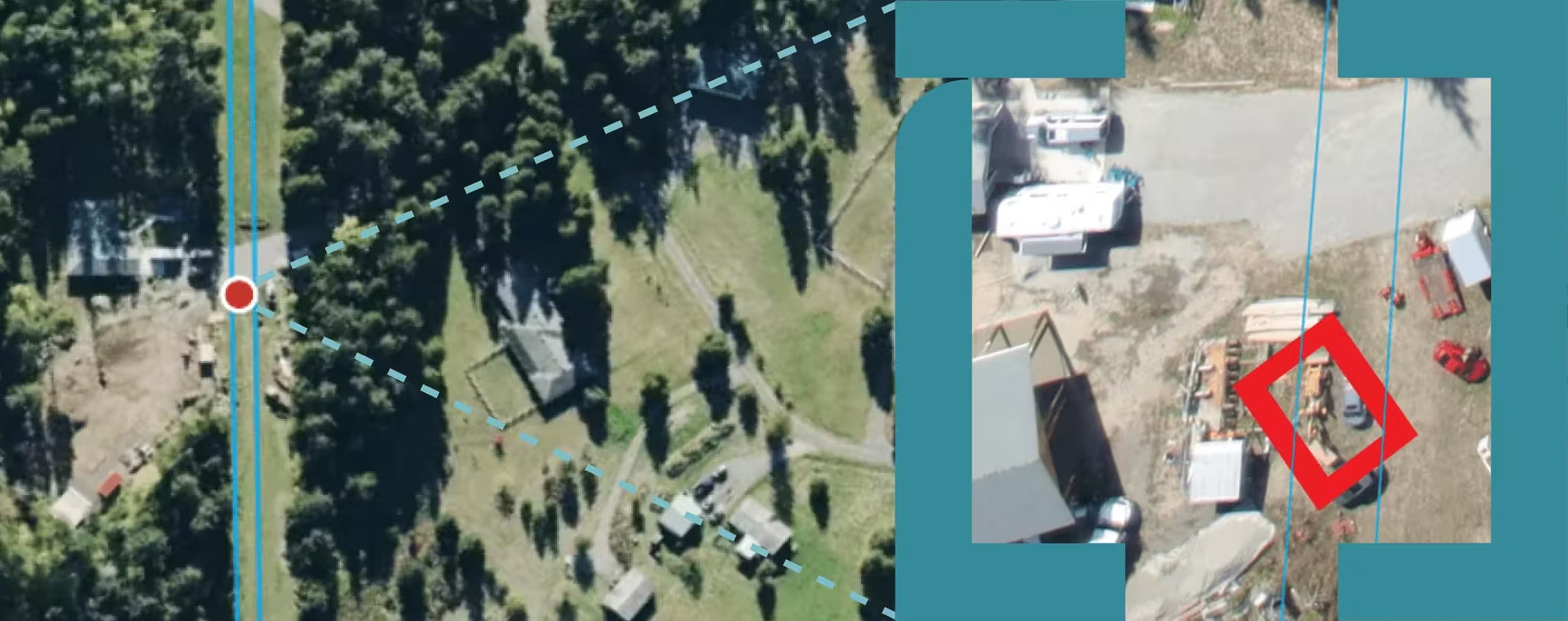
Weekly high-resolution oriented oblique imagery is captured along the ROW centerline and paired with AI object detection models trained on years of operator-specific historical data. This extends threat detection well beyond the ROW itself, providing on-plane edge intelligence for augmented in-flight decision support directly to pilots during patrol.
High-Resolution Multi-Threat Detection. AI models identify and flag vehicles, heavy equipment, excavation, ground disturbance, and construction activity at 3–5 cm resolution
Extended corridor Analytics. Captures a 400-metre (approx 1300 ft) corridor (200m or approx 650 ft) per side) to identify subtle precursors like pallets or new fencing well beyond the ROW boundary
Detection extends to subtle precursors: pallets, new fencing, minor ground disturbance, and off-ROW equipment
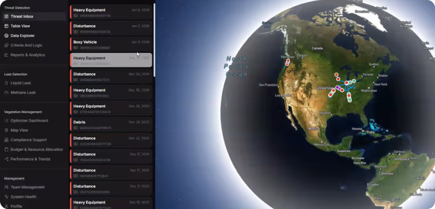
The Command Center centralizes threat detections, leak reports, and LIDAR analytics into a single operator interface. By providing full transparency into ROW risk and surfaces high-priority threats and the leading indicators that precede them — often weeks before a potential line strike risk develops.
Automated AI threat detection on every flight — high-priority threats surfaced directly to operators
Precursor detection: homeowner construction, equipment staging, new fencing, and ground disturbance flagged before escalation
Historical trend views and change-over-time comparison at any location along the system
Automated operator notifications with actionable context and imagery
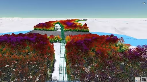
LiDAR-derived individual tree inventory feeds an optimization solver that runs hundreds of thousands of simulations to determine the optimal multi-year clearing schedule. It accounts for species-specific growth rates, terrain, contractor mobilization costs, and regulatory requirements — automating decisions that traditionally require large vegetation management teams.
Individual tree inventory with density and risk scoring across the full ROW corridor
Optimization solver determining the most cost-effective multi-year clearing schedule
Species-specific growth rate modeling to forecast future clearance violations
Consistent 2:1 annual return on investment delivered to operators
.png)
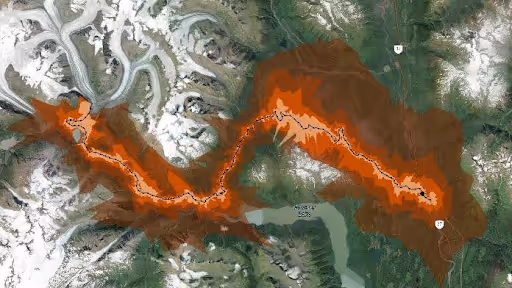
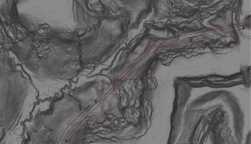
Leaf-off, snow-free LiDAR collection detects ground movement, erosion, and landslide risk along pipeline corridors. Multi-year DEM comparison tracks subsidence and terrain change over time — paired with weekly aerial patrol imagery for continuous ROW integrity monitoring.
High-resolution DEM and hillshade comparison across collection cycles for subsidence and slope detection
Erosion and landslide risk flagging from terrain change analysis
Predictive analytics for subsidence, slope instability, and watercourse migration
Integration with aerial patrol imagery for continuous ground movement surveillance
Predictive wildfire risk modeling — drawn from Forsite's forestry and utility wildfire programs — applied to pipeline corridors. Protects assets, informs operational decisions during fire season, and supports regulatory compliance.
Corridor-level fuel mapping and fire behavior modeling
Worker health and safety risk assessment during fire season operations
Asset and infrastructure risk modeling for regulatory compliance documentation
Social licensing support — community risk communication and stakeholder reporting
PRIMARY USE CASES
Where Patrol Intelligence
Delivers Outsized Value
Compliance and Audit-Readiness
Oriented imagery and digital patrol records provide a traceable, defensible documentation chain for every flight.
Individual tree volumes, crowns, and product distributions support precise unit design
ESRI OIC-integrated oriented imagery providing full ROW visual context
Variable cadence tracking with no-fly-zone compliance logic
Geohazard Monitoring
Multi-year LiDAR change detection paired with weekly aerial patrol imagery for continuous ground movement surveillance.
Erosion and landslide risk flagging with terrain change tracking across collection cycles
DEM and hillshade comparison for subsidence and slope instability detection
Predictive analytics for emerging geohazard risk
Asset Inventory and Class Location
Continuous imagery and LiDAR support structure identification, class location analysis, and HCA/MCA compliance for both gas and liquid systems.
New structure detection and change-over-time tracking for HCA/MCA boundary management
Building classification support for class location analysis
Depth-of-cover indicators and low-cover flagging from terrain analysis
Aerial Patrol vs Satellite Monitoring
PatrolView™ sees what satellites can’t.
A backhoe on the right-of-way is a strike waiting to happen — the leading cause of pipeline failures. At 50 cm, a satellite can’t resolve it. See the comparison.
Aerial patrol
50 cm satellite
Excavator identified and flagged
Lost under the canopy
Third-party encroachment, exposed pipe and liquid releases — located and reported to you.
Frequently Asked Questions
What is the Command Center?
The Command Center is the unified operator platform where all threat detections, leak reports, compliance data, imagery, and analytics converge. Operators can view automated threat alerts, compare any location along their system over time, manage escalations, and access their full historical imagery archive — all in one place. It is the operational interface that connects every Pipeline Intelligence capability into a single workflow.
What imagery do you capture and how do operators access it?
We capture high-resolution oriented oblique imagery at 3–5 cm resolution across approximately 200 metres / approx 650 ft on either side of the pipeline on every flight. Operators access it through a turnkey platform — not a raw file download. They can browse all flight images, compare any location change over time, and access their full historical archive on demand. The cost per mile is significantly lower than satellite imagery at substantially higher resolution.
What types of threats can you detect that other approaches miss?
Our approach detects the leading indicators that precede line strikes — not just active encroachments. Using high-resolution imagery, PatrolView™ identifies: homeowners building structures over the pipeline; pallets or equipment staged along the ROW before heavy machinery arrives; new fencing crossing the right-of-way; subtle ground disturbance not present on prior flights; and small equipment being used just outside the ROW boundary. These detections prevent line strikes rather than document them after the fact.
How does the vegetation management optimization work?
The optimization engine translates LiDAR tree inventory data into actual work plans — not just better data delivery. The solver accounts for species-specific growth rates, terrain, contractor costs, regulatory requirements, and dozens of other variables, then finds efficiencies that manual planning cannot. It produces optimal clearing schedules, budget allocation, and work sequencing across the entire system — enabling small teams to manage massive ROW vegetation programs at scale.
How does leak detection work?
Methane and liquid leak sensors fly in tandem on existing patrol aircraft — so operators get continuous leak detection coverage on top of their patrol with no additional sorties and no incremental flight cost. Think of it as a smoke alarm approach: highly cost-effective, continuously monitoring, and designed to catch leaks early rather than investigate after a complaint. Detection results flow directly into the Command Center with change-over-time tracking.
.avif)
Ready to Modernize Your Patrol Program?
Tell us about your assets, risk profile, and current patrol and compliance program. We will align patrol, detection, compliance, and analytics to your operational priorities and regulatory requirements.